Trail Walking La Martre - La Martre l'Artuby 04.05.16  - Photo

La Martre l'Artuby 04.05.16

 Sugg
Sugg

User

© OpenStreetMap contributors
Length
Length
19.6 km
Max alt
Max alt
1143 m
Uphill gradient
Uphill gradient
512 m
Km-Effort
Km-Effort  
26 km
Min alt
Min alt
928 m
Downhill gradient
Downhill gradient
512 m
Boucle
Boucle
Yes
Creation date :
2019-03-22 16:59:12.227
Updated on :
2019-03-22 16:59:12.373

(0 Reviews)

Walking
Walking
5h42
Difficulty : Medium

Scan this QR Code to open this trail in the SityTrail application

FREE GPS app for hiking

Logo SityTrail SityTrail

IGN / Geographical institutes

Download SityTrail from the App Store Download SityTrail from Google Play

Logo SityTrail SityTrail Plus

The world is yours!

Download SityTrail from the App Store Download SityTrail from Google Play Download SityTrail on Huawei AppGallery

About

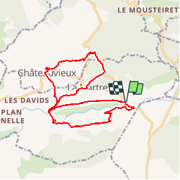
Trail Walking of 19.6 km to be discovered at Provence-Alpes-Côte d'Azur, Var, La Martre. This trail is proposed by Sugg.

Description

Rando RF
Guide : Fernand au départ de la zone picnic en 1006.
Direction La Martre par le chemin des fours à chaux, puis la boucle Nord pour revenir à Châteauvieux, puis Pont de Madame, vallon des Combes, et Pont des Passadoires.
Belle journée ensoleillée, très beaux points de vue.

Elevation profile

Positioning

Country:
France
Region :
Provence-Alpes-Côte d'Azur
Department/Province :
Var
Municipality :
La Martre
Location:
Unknown
Start:(UTM)
308296 ; 4848583 (32T) N.


Close
My subscriptions